Students can Download 1st PUC Geography Model Question Paper 1 with Answers, Karnataka 1st PUC Geography Model Question Papers with Answers helps you to revise the complete Karnataka State Board Syllabus and score more marks in your examinations.
Karnataka 1st PUC Geography Model Question Paper 1 with Answers
Time: 3 Hrs
Max. Marks: 100
Note:
- Answer all questions.
- Draw maps and diagrams wherever necessary
- Questions No.V is on Cartography.
I. Answer the following in a word or a sentence each. ( 1 × 10 = 10 )
Question 1.
Which branch of Geography deals with heavenly bodies of the space?
Answer:
Astronomical Geography is the study of the heavenly bodies of the space
Question 2.
What is an ‘Orbit’?
Answer:
The path on which the earth revolves around the Sun is called ‘Orbit’.
Question 3.
What is Volcano?
Answer:
A volcano is an opening in the crust of the Earth through which heated materials consisting of gases, hot water, lava and fragments of rocks are ejected from the interior of the Earth.
Question 4.
What is weathering?
Answer:
The process of disintegration and decomposition of rocks is known as “Weathering”.
Question 5.
What is Stratopause?
Answer:
Stratopause is the boundary between Stratosphere and Mesosphere.
![]()
Question 6.
What is Salinity?
Answer:
It refers to the amount of dissolved solids in the ocean water. In other words. It means the amount of salt in the ocean water. ”
Question 7.
Define the term Biodiversity.
Answer:
The varied range of flora and fauna found within a specified geographic region is called ‘Biodiversity’ .
Question 8.
In which Island of India, is ‘Indira Point’ situated?
Answer:
Indira point located at Great Nicobar Island.
Question 9.
Mention the major stream of river Ganga.
Answer:
The two major streams are Alakananda and Bhagirathi.
Question 10.
What is drought?
Answer:
The term drought is applied to an extended period when there is a shortage of water availability due to inadequate precipitation, excessive rate of evaporation and over utilization of water from the reservoirs other storages, including the ground water.
II. Answer any ten of the following in two or three sentence each. ( 2 × 10 = 20 )
Question 11.
How is Geography a discipline of synthesis?
Answer:
It is considered to be a liaison subject. It recognizes the fact that the world is a system of interdependency. Geography as an integrating discipline stands midway between Natural Science and Social Science.
Question 12.
What is inclination of the Earth?
Answer:
The Earth’s axis is not at right angle (perpendicular) to the plane of the elliptical orbit. The axis is inclined at an angle of 66 1/2° to the plane of the orbit. This is known as ‘Inclination of the Earth’s axis’.
Question 13.
State the difference between Focus and Epicenter.
Answer:
The point in the interior of the Earth from where the earthquake tremors originate is called the seismic focus. Earthquake tremors move from the focus in all directions.
The point o the Earth’s surface vertically above the focus is called the epicenter. The Earthquake is felt first at the epicenter.
Question 14.
Distinguish between Oxidation and Hydration?
Answer:
The rain water with oxygen reacts on rocks containing iron and produce oxides. This chemical reaction is known as Oxidation.
The rock minerals take up water, the increased volume creates physical stress within the rock.
As a result certain minerals like feldspar and gypsum are reduced into powder. This process is ‘ called “Hydration”.
![]()
Question 15.
Mention the features of Inversion of Temperature.
Answer:
It is a process of temperature increases with increasing height in troposphere. This feature is common during winter season, less cloudiness, slow movement of winds, and clear sky in the mountain valley.
Question 16.
Mention the divisions of Atlantic Ocean currents?
Answer:
There are three divisions of Atlantic Ocean currents are a. Equatorial currents b. Current of North Atlantic Ocean and current of South Atlantic Ocean.
Question 17.
Mention any four types of biomes.
Answer:
Major types of biomes are a. Forest biome b. Savanna biome c. Grassland biome d. Desert biome
Question 18.
Name the water bodies that surround India.
Answer:
India is a peninsula, located at the north tip of the Indian Ocean. It is bordered by the Arabian Sea in the west, Indian Ocean in the south and Bay of Bengal in the east.
Question 18.
Mention any four consequences of natural hazard and disasters.
Answer:
The most important consequences of natural disasters are los of human life and property, animal wealth, destruction of vegetation etc. Natural disasters create fear, anguish and trauma in the human beings leading to various physical, biological and psychological changes. Natural disasters affect population, its distribution and density. It affects on agriculture, cropping pattern, industries, transport and communication, public health, water supply.
Question 19.
What is Biogeochemical Cycle?
Answer:
The cyclic movement of elements of the biosphere between living organism (the biotic phase), and their non-living (a biotic) surroundings (e.g. rocks, water, air etc.) is termed biogeochemical Cycle.
![]()
Question 20.
What is meant by the word ‘Monsoon’?
Answer:
The word ‘Monsoon’is derived form the Arabic word ‘Mausam’which means season. Hence, the word ‘Monsoon’ implies the seasonal reversal in the wind pattern over the year. It reveals the rhythm of season and changes in direction of winds. There is also ca change in the distribution pattern of rainfall and temperature, with the change of seasons. The monsoon winds move six months from sea to land and another six months from land to sea.
Question 21.
Name any four factors that affect soil erosion.
Answer:
High Temperature, Rainfall wind and waves are the natural agents. Deforestation, over grazing, shifting cultivation, unscientific methods of agriculture cause soil erosion.
Question 22.
Write the salient features of Evergreen forest.
Answer:
These forests are found in the.regions of heavy rainfall (above 250 cm) and high temperature (above 27° C) Tall umbrella shaped trees with dense assemblage is a prominent feature of this forest. The evergreen forests always look green because, various species of trees are found here and they shed leaves in different seasons.
III. Answer any eight of the following in 25 to 30 sentences each. ( 5 × 8 = 40 )
Question 23.
Explain the important branches of Physical geography. (T. B. Qn)
Answer:
1. Physical Geography.
The field of physical geography is wide as it includes the study of the entire surface of the earth and also its physical and biological process as well as their morphology. Modern geography has witnessed the development of many branches and some of them even grown into separate disciplines.
Some of the important branches of physical geography are as follows:
- Geomorphology: It is a systematic study of landforms, such as mountains, plateaus, plains, valleys, etc.
- Climatology: Climatology encompasses the study of structure of atmosphere and elements of climates and climatic types and regions.
- Meteorology: The scientific study of atmosphere condition is called meteorology.
- Pedology: It is the scientific study of soil formation, structure, texture, chemical composition and their influence on plant growth.
- Hydrology: Hydrology studies the realm of water over the surface of the earth including oceans, lakes, rivers and other water bodies and its effect on different life.
- Seismology: It is the study of Earthquakes, their effects and distribution.
- Astronomical Geography: It is the study of heavenly bodies of the space like planets, satellites, stars etc in relation to the earth.
- Volcanology: It is the scientific study of tectonic process of volcanoes.
- Astronomical geography: It is the study of heavenly bodies of the space like planets, satellites, stars etc in relation to the earth.
- Bio-geography: It is the systematic study of the distribution of plants and animals.
- Hydrology: The study of water on the earth’s land is known as hydrology.
- Oceanography: The study of waves, tides and currents and the other characteristics of oceans, known as oceanography.
2. Human geography: It deals with man and his activities particularly cultural environment factors on man made factors, Important among them are culture, Society, agriculture, mining, industry, transport forming trade population etc.
Some of the important grander of Human geography are as fallows:
- Political geography: It deals with spatial unit, people distribution, political behavior, political divisions etc.
- Economic geography: It refers to basic attributes of the economy such as production, distribution exchange of goods and consumption. It deals with the spatial aspects of production, distribution and consumption and also helps on understanding the most proper location for establishing different human activities.
- Commercial Geography: It deals with the spatial distribution of trade and commercial practices etc.
- Population Geography: It helps to understand the distribution, growth density, migration and various other components of population.
![]()
Question 24.
Explain the effects of the rotation of the Earth. (T.B. Qn)
Answer:
Rotation of the Earth causes various effects. They are:
a. Day and night caused by the rotation of the earth on its axis. This is because parts of the earth which face the sun have day and the parts which do not face the sun have night. This happen with precision and progression and not suddenly – The time when the sun beings to cast its light in the sky is known as dawn. At noon. The sun is overhead. At dusk, it is twilight and the sun is seen disappearing in the sky. At night, it is completely dark.
b. The duration of the day and night is not equal at all places on the earth because of the inclined axis. The length of days varies with respect to the seasons as well as latitude
c. The sun, the moon and the stars seem to move from east to west. This is because the earth spins from west to east. This effect is similar to what one experiences while looking at trees from a moving train.
d. The speed of rotation has created a centrifugal force resulting in a bulge in the middle portion of the earth and flattened top at the poles.
e. The earth’s rotation affects the movement of water in the oceans. The tides are deflected because of the rotation of the earth.
f. Rotation causes difference in time over various places on the earth.
g. The Earth acts as huge magnet: The one end of the needle of the compass always points towards the north magnetic pole. That means, the earth acts as a magnet. The rotation . of the earth causes the earth to act as a magnet.
h. Rotation of the Earth influences the movement of ocean water, particularly ocean currents.
i. The rise and fall in the sea level is called tides. Rotation of the Earth causes the lacing of water bodies to the Moon. The gravitational attraction of the Moon and position of the water bodies cause tides. This is a regular phenomenon due to Earth’s rotation.
![]()
Question 25.
What is an Earthquake? Describe the causes and effects of earthquake. (T.B.Q)
Answer:
An Earthquake is a sudden vibration or oscillation in the Crust of the Earth. It is a form of energy of wave motion transmitted through the surface layer of the Earth. The place of origin of an Earthquake in the Earth’s crust is called ‘Focus’. The point on the Earth surface which is perpendicular to the focus, receiving seismic waves is called ‘Epicentre’.
Causes of Earthquake: On the basis of occurrence earthquakes can be classified into three types. They occur due to several causes such as tectonic forces, folding, faulting, volcanic eruptions landslides, avalanches, man-made factor.
Tectonic Earthquakes: These are caused due to folding, faulting and displacement of blocks of rocks in the Earth’s crust. They are highly intensive and destructive seismic activities.
Volcanic Earthquakes: These are associated with the volcanic activities and are usually caused at great depths. They are with low intensity and magnitude. The destruction and damage are slightly lesser than earthquakes caused by Tectonic forces.
c. Earthquakes caused by man-made factors: Over interaction of man underground nuclear explosion etc, are causing great change in the crustal formation leading to seismic activity. E.g. Koyna dam (India)-1967, Hoover dam (U.S.A)-l 935, Mangladam (Pakistan). Effects of Earthquakes: Earthquakes cause violent disturbances and widespread damage and destruction, especially on the epicentre region.
- Earthquakes cause changes in the earth’s surface. Cracks and fissures develop in the earth’s crust.
- Vibrations, caused by earthquakes, lead to landslides in mountainous regions, damming the rivers.
- vertical or horizontal cracks are formed, and the land is elevated or lowered, forming lakes.
- Deep cracks may be developed in dams after the earthquake. For instance, deep cracks were developed in the Koyna dam after the earthquake.
- The beds of rivers may be raised by the earthquakes. For example, the bed of the river Brahmaputra was raised during the Assam earthquakes.
- here is the greatest danger of falling of houses, roads railway lines factories, bridges, dams, aerodromes, and other man-made structures, resulting in loss of life and property.
- The underground water system is disturbed.
Question 26.
Explain chemical weathering with examples.
Answer:
Disintegration and Decomposition of rocks by chemical processes is called “Chemical weathering”.
In this process secondary or new minerals are developed from the original minerals of the rocks. The rain water and atmospheric gases are the main agents of chemical weathering. It is vey common in humid regions.
There are four types of chemical weathering process. They are:
- Oxidation: The rain water with oxygen reacts on rocks containing iron and produce oxides. This chemical reaction is known as “oxidation”. The common process of rusting of iron is an example of oxidation.
- Carbonation: The rain water with carbon-di-oxide becomes a weak carbonic acid and it reacts with calcium carbonate or limestone to form calcium bicarbonate, which dissolves easily. This process is called “Carbonation”. It is very active in limestone regions.
- Hydration: The rock minerals take up water the increased volume creates physical stress within the rock. As a result certain minerals like feldspar and gypsum are reduced into powder. This process is called “Hydration”.
- Solution: The rain water is able to dissolve some of the soluble minerals, such as rock- salt, gypsum, potash. This process is called “Solution”.
Question 27.
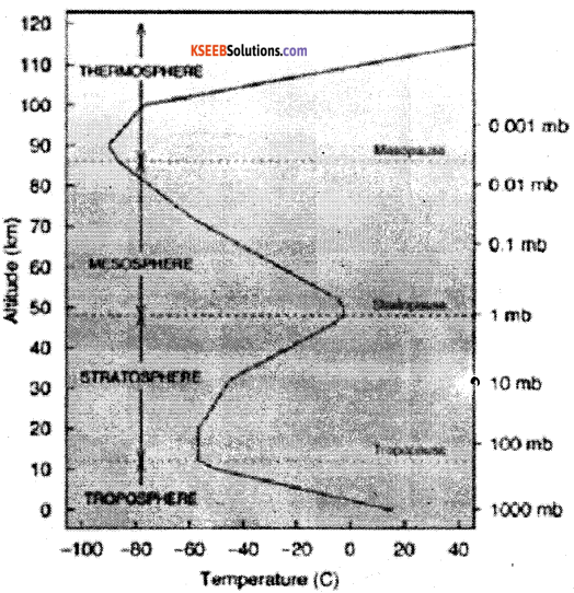
Explain the structure of the atmosphere.
Answer:
The distribution of temperature is not uniform at different height of the atmosphere. Along with the variation of temperature there are unique features at different heights. Based on these characteristics atmosphere is divided into four parallel zones.
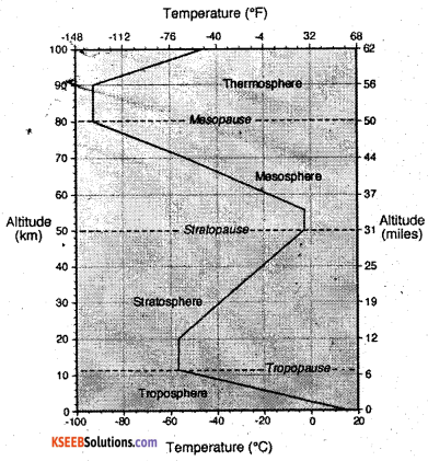
1. Troposphere: It is the lowest layer of the atmosphere and les closer to the earth. The word ‘Tropos’ means ‘turn’ It extends up to 18km at the equator and 8km at poles. Thus the average height is about 10-12km. The important feature of the troposphere are:
Hydrological cycle: It is confined to troposphere. The water evaporates and raised up, formation of clouds takes place. Later it is precipitated in various forms like rain, snow and hailstone. These processes are known as evaporation, condensation and precipitation.
Lapse rate: In this layer the temperature decreases at the rate of 6,5’ Celsius per every 1000 meters of height which is known as ‘lapse rate’.
Clouds: It is characterized with formation of clouds, thunder storms and lighting.
Gaseous Mass: The troposphere has about 75 percent of the total gaseous mass, The upper part of troposphere is known ‘Tropopause’.
2. Stratosphere: It lies above the tropo-sphere and extends up to 50km from the earth. The temperature is also most unifonnly distributed. Hence it also known as isothermal zone. At a height of 22kms. There is a thin layer of ozone which absorbs ultraviolet rays of the sun. So it is called as ozOnosphre. The name staratopause is given to the upper part of the stratosphere.
3. Mesosphere: It extends from 50 to 80kms. It is an intermediary zone between the lower and upper layers of the atmosphere. A thin layer of air separating mesosphere from the other upper layers in named as‘Mesopause’.
4. Ionosphere: It extends from 90 to 500km. It consists of atoms of air ionized due to intensive temperature. So it is also known as ‘Ionosphere’or Thermosphere. The radio waves of different length are reflected back from this layer.
5. Exosphere: The region beyond the Thermosphere is called Exosphere. It extends to about 1,000 km and the gravity of the Earth s too weak in this layer. Magnetosphere is found above this layer. Atmospheric layer in between 500-700kms is known as Exosphere and the atmosphere lying beyond is called‘Magnetosphere’.
![]()
Question 28.
What is a mineral? Explain the types of minerals.
Answer:
Mineral is a natural inorganic substance which has certain chemical and physical properties. The scientific study of minerals is called Mineralogy. Minerals are used by man for various human activities. Understanding them minerals their types and uses is very important as natural resources of the earth.
Types: Minerals are classified into different types on the basis of nature, texture, and sues. Important among them are,
- Metallic Minerals: These minerals are not in metallic form and they do not contain metal. A few non-metallic minerals are Mica, Asbestos, Sulphur, lead, Zinc, Phosphate etc.
- Non-Metallic Minerals: These minerals are not in metallic form and they do not contain metal. A few non-metallic minerals are Mica, Asbestos, Sulphur, Lead, Zinc, Phosphate etc.
Minerals are also classified into other types.
Ferrous minerals which contain Iron e.g. Iron Ore. Non-ferrous minerals – these minerals do not contain ferrous e.g. Bauxite, Mica. – A few minerals are used for making decorative, commercial and precious ornaments are called Precious minerals. E.g. Platinum, Diamond, Gold and Silver. Some minerals are use for the generation of energy. They are Nuclear or atomic minerals e.g. Uranium, Thorium etc.
Question 29.
What is landform? Explain the different types of geomorphic processes?
Answer:
A land form is any natural formation of rock and dirt, found on the earth. A landform can be as. large as a mountain range or as small as a hill. Landforms are natural features of the landscape, natural physical features of the earth’s surface eg. Valleys, plateaus, Mountains, plains, hills loess plains. The minor landforms include hills, ridges, valleys, basin etc. According to Geo-scientist the landforms are formed by the forces acting from the interior and on the surface of the Earth.
The processes carried out by Endogenic and Exogenic forces are called geomorphic processes. Endogenic forces: The internal forces are also known as endogenic forces. These are mainly the land building forces. Diastrophism includes all these processes; that move, elevate or build portions of the earth’s crust.
The internal forces are also known as endogenic forces. Exogenic Forces: The external forces are also known as Exogenic forces. These forces are found on the surface of the Earth, Which bring changes through degradation and aggradations process. River, glacier, wind, sea waves are the major sources of external forces.
Question 30.
Explain the topography of the Ocean floor with a diagram.
Answer:
On the basis of the depth, the ocean floor can be divided into four zones, parts or relief features. They are.
1. The continental Shelf: The gently sloping portion of the continent or land that lies submerged below other sea is called the continental shelf. The continental shelf has a very gentle slope. It extends form the shore line to depths between 180 and 200 meters. Average width of the continental shelves is about 48km. The extent of the continental shelf depends on the relief of the broadening land masses.
If the coastal area is a plateau area, the continental shelf will be very broad. On the other hand, if the coastal region is hilly or mountainous, the continental shelf will be very narrow or even absent for example the Atlantic Ocean has 2.3%, the Pacific Ocean has 5.7% and the India Ocean has 4.2%.
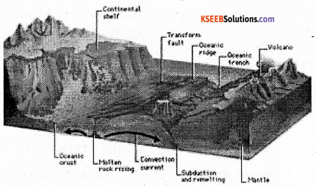
2. The continental slope: The zone of steep slope that descends from the edge of the continental shelf to the deep sea plains is called “continental slope”. It is the transitional zone lying between the continental shelf and the deep sea plains. The continental slope is very steep. It extends from 182 meters to 3.600 meters. The angle of the continental slope is 2 to 5 degre3es or even more. It occupies only 8.5% of the total area of the ocean floor. But it varies from ocean to ocean. The Atlantic Ocean has broader continental slopes and accounts for 12.4%. But it is 7% of the Pacific Ocean and 6.5% of the Indian Ocean.
3. The deep sea plains: The level and rolling areas of the ocean floor are generally called deep sea plains or abyssal plains or the ocean plains. They lie between 3,000 and 6,000 meters below other surface of the ocean. They occupy vast area of the ocean floor and account for about 82.7% of the total sea floor. They cover about 90% in the Indian Ocean. Their depth ranges from 5,000 to 6,000 meters. They are covered by oozes, which are the remains of deep sea creatures and plants, and of red volcanic dust.
4. The Ocean Deeps: The long narrow and deep troughs on the ocean floor are known as ‘ocean deep’ or ‘trough’. They cover only 1% of the ocean floor. They are most common neat the coasts where young fold mountains, volcanoes and earthquakes abound. Some they are tectonic in origin. They are the deepest portions of the ocean. Deeps may be caused due to tectonic forces, i.e. faulting earthquakes etc. There are 57known deeps. Of these 32 are found in Pacific Ocean, 19in the Atlantic Ocean and 6 in the Indian Ocean. The deepest trench in the world is Challenger deep located in Mariana Trench to the west of Philippines in the North Pacific Ocean.
Question 31.
Briefly explain the Coastal plains of India.
Answer:
This is the region all along the Indian coastline, lying between the coast and the mountain ranges of the peninsular plateau. India has 6100 km from Gujarat in the west to West Bengal in the east. The average width is 10-25 kms. The coastal plain of India is divided into two parts.
The West Coastal plains: It is extends between the Arabian Sea and the Western Ghats. It is narrower than the east coastal plains, stretching to a length of about 1400km and width of 10 to 80km from the Rann of katchchh to Kanyakumari. The west coastal plains have Gujarat, Konkan, Karnataka and Malabar Coasts.
The Gujarat Coast comprises of Rann of Kachchh and Cambay coasts. It is formed by the alluvial deposits of Sabarmati, Mahi, Luni and other small streams. Gujarat has the longest coastline in India Kandla and okha are famous sea ports and along is the biggest ship breaking center. It produces highest salt in the country.
Konkan Coast lies to the south of Gujarat coast and extends line which provides suitable site for natural seaports. Eg: Mumbai, Navasheva, Marmagoa, Karwar, New Mangalore etc., this coast records highest coastal erosion. It is very rich in Petroleum and natural gas. Karnataka coast: it is a part of Konkan coast.
It extends from karwar in the north to Mangalore in the south. It is the narrowest part of west coastal plains. Karwar and New Mangalore are important ports in this belt. Sea Bird, the naval base near Karwar is the largest naval base in India.
The Malabar Coast extends from Mangalore to Kanyakumari, Sand dunes, lagoons and backwaters are the important features of this coast. Cochin or Kochi is the biggest seaport in this coast. Backwaters of Kerala facilitate navigation and tourists enjoy traveling though small country boats. The first south west monsoon rainfall is received in this coast.
East coastal Plains: It lies between the Ea’stern Ghats and the Bay of Bengal stretching from the delta of Hooghly in the North to Kanyakumari in the south. Compared to the west coastal plains the east coastal plains are broader.
The Tatkal Coast: It is the coastal plain of Orissa state. It extend for about 400kmms, north from Subarnarekha river to south of the Rushikulya river. It has a chilka lake, which is the largest salt water lake in India, Para deep is the important horbour located here.
Coromandel Coast: The southern part of east coast is known as the Coromandel Coast. It gets more rainfall from the north east monsoons and it is highly affected by cyclones. The oldest harbor Chennai located here.
![]()
Question 32.
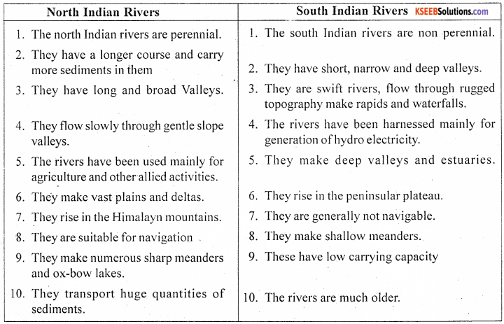
Compare the North Indian rivers with South Indian Rivers.
Answer:
Question 33.
Describe the salient features of Salinity of the Ocean water. (T. B. Qn )
Answer:
Salinity of ocean water refers to the amount of dissolved solids in the ocean water. Ocean water consists of various kinds of chemical elements and minerals. Of these constituents, sodium chloride is the most important constituent of ocean water. The other constituents or salts like magnesium chloride, magnesium sulphate, calcium sulphate, potassium sulphate, etc.
Are also present in the ocean or sea water. The ocean water is saline by the rivers which bring huge amount of mineral salt dissolved in water. Another reason for salinity is the evaporation of sea water, by which mineral salt in the sea or ocean water increase every year. Salinity is measured in gram per kg of sea water and it is expressed as part per thousands for examples: 35% it means 35gram of salt in 1000 gram of sea water.
Factors affecting the salinity in the ocean water are: Evaporation, Precipitation, and Fresh water mixing with ocean water, ground water and glaciers increase the percentage of salt content in the ocean. The trade winds drive away saline water to less saline areas resulting the variation of salt content.
Latitudes, precipitation, mixing of fresh water etc. influence on the horizontal and vertical distribution of salinity. The regions near Tropic of Cancer and Capricorn record high salinity due to high temperature, more evaporation, low rainfall and extensive arid and semi-arid areas. While the equatorial region record low sanity because of high temperature and high rainfall. The polar region record least salinity due to very low temperature, evaporation and less rainfall.
Question 34.
Explain the anticyclones.
Answer:
Winds blowing spirally outward from centers of high pressure are known as anti-cyclones. They are just the reverse of cyclones. Their movement is clockwise in the Northern Hemisphere and anti clockwise direction in Southern Hemisphere. They are more common in the sub¬tropical high pressure belts and absent in the equatorial belt. They are circular in shape, larger in size and extent and their track is highly variable. The weather is generally associated with anticyclones is find and dry.
The anticyclones are divided into two groups such as permanent and temporary anticyclones.
Permanent anti-cyclones are mainly centre in the temperate regions where the meeting of tropical and temperate air mass takes place. In between the two temperate cyclones there will be anti-cyclones. In the interior of continents the high pressure centers are developed during the winter season. It is due to lower amount of temperature.
IV. Answer any one of the following. ( 10 × 1 = 10 )
Question 35.
Explain the planetary winds with the help of diagram. (T. B. Qn )
Answer:
Winds which blow from high pressure belts to the low pressure belts in the same direction through out the year are called planetary winds, permanent winds or prevailing winds. Characteristics: The chief characteristics of planetary winds:
- They are connected with the pressure belts. So they blow from the high pressure belt or area to the low pressure belt or area.
- They are regular through out the year.
- They deflect to their right in the northern hemisphere and to their left in the southern hemisphere.
- As a result of the shifting of the pressure belt northward in summer and southward in winter, the planetary winds also shift northwards in summer and southwards in winter. They are permanent and blow over vast areas of the globe. These winds include trade winds, westerlies and polar winds.
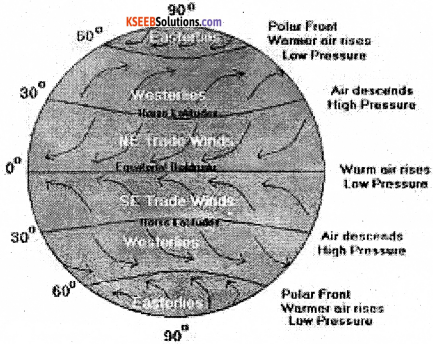
1. Trade winds: The winds that blow in the tropics form the sub-tropical high pressure belts towards the equatorial low pressure belt are called “Trade winds”. They found approximately between 8° and 30° latitudes on both sides blowing from the east. They are also known as “Tropical Easterlies”.
The trade winds due to the law of deflection blow from the north-east in the northern hemisphere and from south-east in the southern hemisphere. Trade winds blow from the cooler sub-tropical areas to the hotter area, hence they do not bring rain. However, when they blow over the open sea they gather moisture and bring heavy rainfall to the east coast of the continents.
2. Anti trade winds: The wind blowing from sub-tropical high pressure belts towards sub-polar low pressure belts are known as anti-trade winds. They are south-west to north east in the northern hemisphere and Norwest to south-east in the southern hemisphere.
Hence they are called ‘Westerlies”. They prevail largely between 40° and 650 north and south of the equator. They blow from the north-west in the southern hemisphere and south – west in the northern hemisphere. As they blow from hotter areas to colder areas they bring rain through the year.
3. Polar winds: Winds blowing from polar high pressure belts toward the sub-polar low pressure belts are known as polar winds. They blow from the north east in the northern hemisphere and south east in the southern hemisphere. As they blow form the snow cov4red areas they are very cold winds. They are constant in the southern hemisphere.
Question 36.
Explain the structure and composition of the Earth with a neat diagram. (T.B.Qn)
Answer:
On the basis of the physical and chemical properties of the earth’s surface, behavioral patterns of seismic waves of earthquakes and the lava erupted form volcanoes, it is generally held that the earth is composed of three layers or parts.
1. The crust: The outer or upper most layer of the earth is the crust. It is solid and is the thinnest and lightest part. It is 6to 60 kms thick. It has two layers.
a. Continental crust or sial: The upper part consist of sedimentary and granite rocks’ and forms the continents. Its major constituent elements are silica and aluminum. So, it is termed as sial. Its average thickness ranges between 10-12 km.
b. Oceanic crust or Sima: The lower part of other Crust is known as oceanic crust. Its thickness is around 5 km. This layer is rich in silica and Magnesium. Therefore, it is called Sima. The lower continuous layer is mostly composing of silica and magnesium and so it is termed as sima. The mean density of this layer is 2.95gm. Conrad discontinuity between Sial and Sima and Mohorovicic discontinuity between Crust and Mantle are the major discontinues in the crust.
2. The Mantle: The portion of the earth’s interior, lying beneath the crust and above the core is known as mantle. It is largely made up of basic silicates, rich in iron and magnesium. It extends from 60 to 2,900km. The density of this layer from 3.3 to 5.7gm. The mantle has two parts.
a. Upper Mantle: This is the outer layer of the Mantle known as Asthenosphre. Most of the earthquakes and volcanoes take birth due to disorder in this layer.
b. Lower Mantle: This is the lower layer of the Mantle known as Mesosphere and it is in solid form. Repetti discontinuity between Asthenosphere and Mesosphere and Gutenberg discontinuity between Mantle and Core are the major discontinues in the mantle
3. The core: The core is the central part of the earth’s interior. It extends from the lower boundary of the mantle to the centre of the earth for about 6,400 kms. The most important materials of core are nickel and ferrous (Nife). The core consists of two layers, namely.
a. Outer core: It is the outer layer of the Core consisting hard molten rocks. Most of the materials are in molten form. It extends from 2900km to 4980km.
b. Inner core: It is the lower layer of the Core with very high temperature and pressure. Most of the materials are in solid form therefore, it is called solid core. The average temperature of this layer is around 2900° C. Transition discontinuity is found between Outer. Core and Inner Core.
![]()
V. (A) Answer the following in a sentence each. ( 1 × 5 = 5 )
Question 37.
What is Cartography?
Answer:
The science and art of making maps, charts, globes and rile models is known as Cartography.
Question 38.
Define Map.
Answer:
A map is defined as a symbolical and conventional representation of the earth or a portion f it drawn to scale on a flat surface and bounded by the geographical coordinates as viewed from above.
Question 39.
What is Scale?
Answer:
A scale is the ratio of the distance between two points on the map and their corresponding distance on the ground.
Question 40.
What is Index?
Answer:
The features show on a map is indicated by a guide called map index.
Question 41.
Give an example for small scale map.
Answer:
Small Scale maps: The Maps drawn on the scale below 1 cm: 15Km or 1:15,00,000 eg. Atlas and Wall Maps. These maps show broad physical and cultural features.
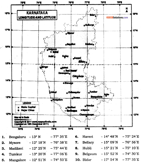
(B) Identify the latitudes and longitudes for the given places. ( 1 x 5 = 5 )
42. Mysore
43. Tumkur –
44. Mangalore
45. Haveri
46. Bidar
Answer:
(C) Draw diagrams to the following. ( 2× 2 = 4 )
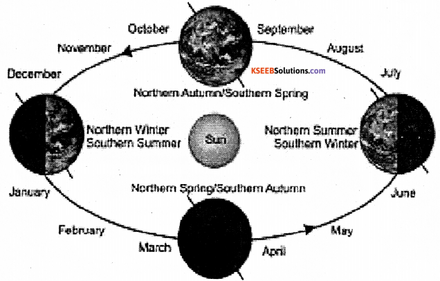
Question 47.
Cycle of Seasons.
Answer:
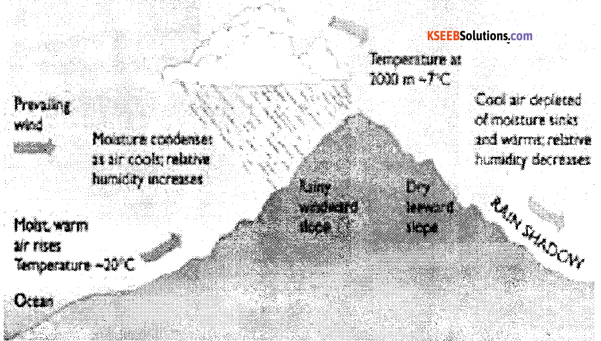
Question 48.
Orographic rainfall
Answer:
![]()
(D) Draw the outline map of India, mark and name the following
Question 49.
Map drawing (2)
Question 50. (2)
Southwest and Northeast monsoon winds
Question 51. (2)
Nokrek and Agasthyamalai biosphere reserves
Answers:
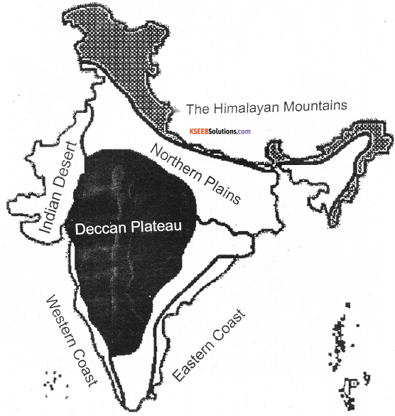
1. Physical divisions of India
![]()
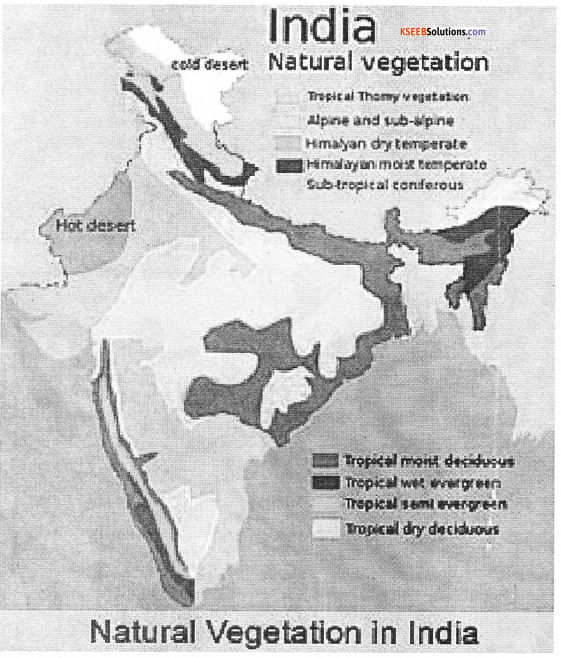
2. Forests of India
![]()
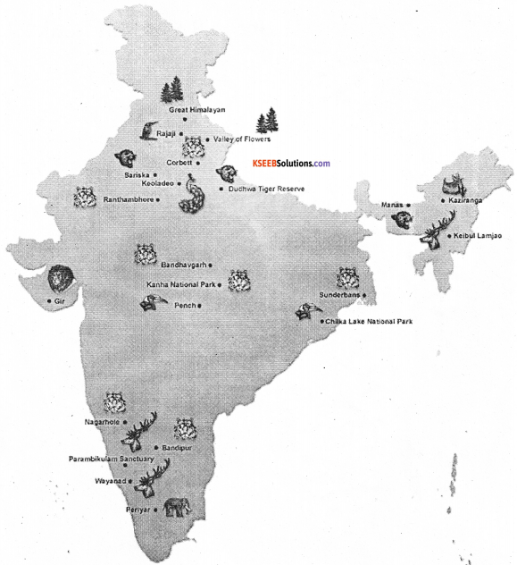
3. National park and Wild life in India
![]()
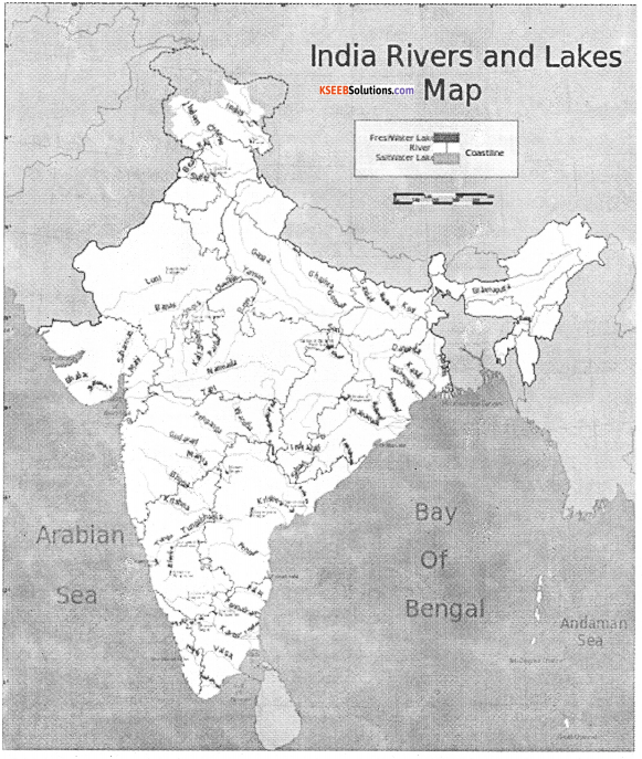
4. Rivers and Lakes
![]()
7. Biosphere Reserves
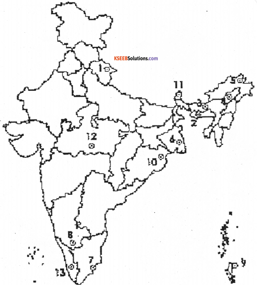
- Nanda Devi Saikhawa
- Nokrek
- Manas
- Dibru
- Dehang Debang
- Sunderbans
- Gulf of Mannar
- Nilgiri
- Great Nicobar
- Similipal
- Khanghendzonga
- Panchamarhi
- Agasthymalai
- Achanakmari – Amar Kantak
![]()