Karnataka 1st PUC Geography Question Bank Chapter 6 Hydrosphere
You can Download Chapter 6 Hydrosphere Questions and Answers, Notes, 1st PUC Geography Question Bank with Answers Karnataka State Board Solutions help you to revise complete Syllabus and score more marks in your examinations.
1st PUC Geography Hydrosphere One Mark Questions and Answers
Question 1.
What is Hydrological cycle? (T. B. Qn)
Answer:
The cyclic (Evaporation, condensation and precipitation) movement of water between the atmosphere and the Earth’s surface is called ‘Hydrological cycle’.
Question 2.
Define Oceanography. (T. B. Qn)
Answer:
The scientific study of water bodies (Sea, Oceans) is called ‘Oceanography’.
Question 3.
Which instrument is used to measure depth of the Ocean? (T. B. Qn)
Answer:
Fathometer is the instrument used to measure the depth.
![]()
Question 4.
Name the region which covers largest area in the ocean floor. (T. B. Qn)
Answer:
Deep sea plains account for about 82.7% of the total area of the ocean floor.
Question 5.
Which hemisphere is called water hemisphere?
Answer:
Southern hemisphere is called water hemisphere.
Question 6.
Define hydrosphere
Answer:
The total water mass on the earth’s surface is called hydrosphere.
Question 7.
Name the four oceans of the world.
Answer:
Pacific Ocean, Atlantic ocean Indian Ocean, Antarctic Ocean and arctic oceans.
![]()
Question 8.
What is a nautical mile?
Answer:
The length, width and areas of oceans is measured by means of nautical miles. One nautical mile measures a length of 6080 feet.
Question 9.
Which is the largest and deepest ocean?
Answer:
Pacific is the largest and deepest ocean in the world
![]()
Question 10.
What is isobaths?
Answer:
Lines drawn the map to show the places having some depth in the sea or ocean floor.
Question 11.
What are Bathy orographical maps?
Answer:
The maps depicting the surface configuration of the ocean floor are called Bathhyorographical maps.
Question 12.
What is Hypsographic curve?
Answer:
It is the curve representing the extent of the area, height and depths of the land as well as oceans.
![]()
Question 13.
What is the average depth of the oceans?
Answer:
The average depth of the oceans 3600 meters.
Question 14.
Which is the deepest part of the oceans?
Answer:
Ocean deep is the deepest part of the oceans.
Question 15.
What is sea level?
Answer:
Sea level is considered as a standard for measuring heights of landforms.
![]()
Question 16.
Which is deepest part of the Pacific Ocean?
Answer:
The challenger deep in the Marina trench near the Philippine Islands in the Pacific Ocean is the deepest part of the Ocean floor (10,898 meters).
Question 17.
What is continental Slope?
Answer:
The portion of the ocean floor from the edge of the continental shelf to the deep sea plains is called the continental slope.
![]()
Question 18.
What is an ocean deep?
Answer:
The ocean deeps are the depressions on the ocean floor with very steep sides.
The long, narrow and deep troughs on the ocean floor are known as ocean deeps or troughs.
Question 19.
What is Salinity? (T. B. Qn)
Answer:
It refers to the amount of dissolved solids in the ocean water. In other words. It means the amount of salt in the ocean water.
Question 20.
Which lines are drawn on the map to show places having same salinity? (T.B.Qn)
Answer:
Isobaths drawn on the map to show the places having same depth in the sea or ocean floor.
Question 21.
Define Iceberg.
Answer:
The huge masses of floating ice are known as ‘Icebergs’. They are found near the polar areas. Usually many of them drift towards the equator during summer and lower the temperature of the ocean water.
![]()
Question 22.
Where does Sargasso sea locate?
Answer:
In the North Atlantic Ocean.
Question 23.
Where does Great Barrier Reef locate?
Answer:
East coast of Australia.
Question 24.
Where does the Australian current flow?
Answer:
Indian Ocean.
![]()
Question 25.
What instrument is used to measure salinity?
Answer:
Electric salinity meter
Question 26.
What are Isohalines?
Answer:
Isohalines are the liens drawn on the map to show the places having the same amount of salinity.
Question 27.
What is the average salinity of ocean water?
Answer:
The average salinity of the ocean water is 35 ppt (parts per thousand) means 35 gms of salt per 1000 grams of sea or ocean water.
![]()
Question 28.
Mention any two determining factors of salinity of ocean water?
Answer:
Evaporation and precipitation are the major determining factors of salinity of ocean water.
Question 29.
What are Sea Waves? (T. B. Qn)
Answer:
Series Waves are the undulations found on the surface of the sea or ocean.
Question 30.
Where do we find the ‘Agulhas current’? (T. B. Qn)
Answer:
Agulhas currents are found in East of South Africa.
![]()
Question 31.
What is meant by Ocean current?
Answer:
Large scale movements of water in the oceans in a definite direction are called ocean currents.
Question 32.
What is wave time?
Answer:
The time of movement from one crest to another or from one trough to another is called wave time.
Question 33.
What is the height of the wave?
Answer:
The vertical distance between crest and trough is called the height of the wave.
Question 34.
What is Trough?
Answer:
The lowest part of the wave is between two waves is called trough.
![]()
Question 35.
What is crest?
Answer:
The highest point of the wave is called crest.
Question 36.
What is wave length?
Answer:
The distance between two successive crests or troughs is called the wave length
Question 37.
Where do you find the Gulf Stream?
Answer:
It is a Warm current, flows east wards from the newfound land, in the east coast of U.S.A
Question 38.
What are the two cold currents of the North Atlantic Ocean?
Answer:
Canary current, East Greenland current and Labrador Current.
Question 39.
Where are the Falkland current and Beguile currents flow?
Answer:
These are two cold currents in the South Atlantic circuit.
![]()
Question 40.
Where do you find Kurosiwo current?
Answer:
Kurosiwo current found in East coast of Japan. It is north pacific current.
Question 41.
Name the two cold currents of the North Pacific Ocean.
Answer:
Oyash.io and Okhotsk current are the cold currents of North Pacific Ocean.
Question 42.
Where do you find Agulhas current?
Answer:
Agulhas current found in South Africa.
![]()
Question 43.
What is ‘drift’?
Answer:
The movement of sea surface water dragged with the prevailing winds is known as ‘drift’.
Question 44.
Mention the types of current?
Answer:
Warm and cold currents.
Question 45.
What are Warm currents?
Answer:
The currents originating in the tropical region have warm waters called warm currents’.
![]()
Question 46.
What are cold currents?
Answer:
The currents which flow from the polar areas carried cold water. These are known ass cold currents.
Question 47.
What is the direction of ocean currents?
Answer:
The direction of the currents is clockwise in the northern hemisphere and anti-clockwise n the southern hemisphere.
Question 48.
Mention the divisions of Atlantic Ocean currents?
Answer:
There are three divisions of Atlantic Ocean currents are a. Equatorial currents b. Current of North Atlantic Ocean and current of South Atlantic Ocean.
![]()
Question 49.
Which is the important occupation of the people living in the costal areas?
Answer:
Fishing. Is the important occupation of the people living in the coastal areas.
Question 50.
Name the most important food item derived from the oceans.
Answer:
Fish Molluscans, crustaceans and many other forms for the preparation of food items.
Question 51.
Name the important marine areas of crude oil production:
Answer:
The Persian Gulf region of West Asia and the North sea bed off Europe is well known for petroleum production. Bombay high in India are the major areas of crude oil.
![]()
Question 52.
How does a tide occur? (T. B. Qn)
Answer:
The regular rise and fall of water level in the world’s sea and oceans is called ‘tides’. Gravitation, attraction of the Moon, Gravitational pull by the Sun and Centrifugal force of the Earth. Causes for the occurance of tides.
Question 53.
What is Tidal period? (T. B. Qn)
Answer:
The time between successive-high tide and low tide is known as ‘Tidal period’.
Question 54.
What is Tide?
Answer:
The regular rise and fall of water level in the world’s sea and oceans is called ‘tides’.
Question 55.
What is tidal current?
Answer:
The different types of inward and outward movement of water are known as Tidal current.
Question 56.
What are neap tides?
Answer:
Neap tides are occur when the earth, sun and moon are not in straight line. The sun and moon are not exerting, sun and moon are more or less in a straight line.
![]()
Question 57.
What are spring tides?
Answer:
The tides which occur when the earth, sun and moon are more or less in a straight line.
Question 58.
What is High tide?
Answer:
The part of the earth facing the moon experience highest rise of sea water called high tide.
Question 59.
What is low tide?
Answer:
The opposite part of the earth experience lowest water lends called low tide or Ebb tide.
Question 60.
Mention the place petroleum production in India?
Answer:
Bombay high
Question 61.
Where is minimita?
Answer:
It is in Japan. It is the example of marine pollution due to the effects of industries located on the bank of Minamata bay in Japan.
![]()
Question 62.
Expand UNCLOS?
Answer:
United nation conservation on Law of the Sea.
Question 63.
When did sea conservation act passed by UNO?
Answer:
The UNO has passed the sea convention Law in 1982.
Question 63.
What is Maritime?
Answer:
The climate which is influenced much by the oceans is known as Maritime.
![]()
Question 63.
Why marine conservation is important?
Answer:
Oceans are the most important parts of the Earth’s natural environment. It is the home for a great variety of life which is threatened by marine pollution. This subchapter introduces causes for marine pollution and needs of its conservation.
![]()
1st PUC Geography Hydrosphere Two Marks Questions and Answers
Question 1.
Name the four submarine relief features of the Ocean floor. (T. B. Qn)
Answer:
The major submarine relief features are
- The Continental slope
- The Continental Slope
- The Deep Sea Plains d. The Ocean Deep.
Question 2.
Mention the important features of Continental Shelf. (T. B. Qn)
Answer:
The shallow submerged extension of continent is called the continental shelf. It is the shallowest part of the ocean with depth varying between 20 to 600m. Its width vary from one ocean to another ranging between 65 to 75km. The width of the shelf is often related to slope of the adjacent land. It is wide along the low lying land and narrow along the mountainous coasts. Nearly 70% of continental shelves are covered with thick deposits of silt, sand, mud and sediments derived from the land.
![]()
Question 3.
Why is ocean deep or trench important in the Ocean bottom? (T. B. Qn)
Answer:
An arc-shaped depression in the deep ocean floor is called ocean deep or trench. These are the deepest parts of the ocean floor. Ocean trenches are produced by the subduction of oceanic crust under continental crust. They resemble step sided valleys or canyons on the land. Trenches or deeps are generally parallel of the coasts facing mountains and along the islands. Great earthquakes and tsunamis generally take birth in this region.
Question 4.
What is sea? Give an example?
Answer:
A part of the ocean either completely or partially enclosed by land is known as a sea. Sea is an enclosed or semi-enclosed body of salt water. In size it is smaller than an ocean. There are partly enclosed seas like the Caribbean Sea, Mediterranean sea, Arabian Sea, Sea of Japan, The coral sea, the Red sea, etc.
![]()
Question 5.
What is Gulf? Give an example?
Answer:
A gulf is an enlarged bay. It is extensive and penetrated far into the land .A gulf is an inlet of the sea, more enclosed than a bay, penetrating further inland. The Gulf of Mexico, the Persian Gulf, the Gulf of Aden.
Question 6.
What is bay? Given an example?
Answer:
A bay is a wide curving indentation in a coastline lying between two headlands. Examples of bays are the Bay of Bengal, the Bay of Biscay, the Hudson Bay, etc.
Question 7.
What is Strait? Give an example?
Answer:
A narrow passage of water connecting two larger water bodies is called a strait, gulf is an enlarged bay. It is a narrow sea passage joining two larger areas of water bodies. The strait of Gibraltar, the Palk’Strait, the Sunda strait, etc. are examples of straits.
![]()
Question 8.
What is Echo sounding?
Answer:
It is a technique of using sound pulses to find the depth of water. Eco sounder is a device for measuring depth of water by sending pressure waves down from the surface and recording the time until the echo returns from the bottom.
Question 9.
What are the three sources of power generation from ocean water?
Answer:
Three sources of power generation from ocean water are:
- Tidal energy
- geothermal energy
- Energy due to ocean temperature differences.
![]()
Question 10.
What is Geo thermal energy?
Answer:
Geo thermal energy in the oceans is associated with fracture zones and volcanoes. It is used as power resource by many countries like U.S.A, New Zealand.
Question 11.
State any four factors that influence on the distribution of temperature in the ocean.
Answer:
Factors affecting the distribution of temperature are latitudes, prevailing winds, ocean currents, unequal distribution of land and water, salinity.
![]()
Question 12.
Mention any four dissolved minerals in the Ocean water. (T. B. Qn )
Answer:
The total amount of dissolved solids in the ocean water is called salinity. The ocean’s salinity consists of various elements. They are Sodium chloride, Magnesium chloride, Magnesium sulphate, Calcium sulphate, potassium sulphate, Calcium carbonate, Magnesium bromide etc.
Question 13.
What factors affect the salinity in the Ocean water? (T. B. Qn )
Answer:
Factors affecting the salinity in the ocean water are: Evaporation, Precipitation, and Fresh water mixing with ocean water, ground water and glaciers increase the percentage of salt content in the ocean. The trade winds drive away saline water to less saline areas resulting the variation of salt content.
![]()
Question 14.
Mention the types of distribution of temperature of ocean water?
Answer:
The distribution of temperature of ocean water is of two types. They are:
- Horizontal distribution of temperature of ocean water.
- Vertical distribution of temperature of ocean water.
Question 15.
What is Horizontal distribution of temperature?
Answer:
The horizontal distribution of temperature of ocean water is influenced by many factors, such as latitudes, depth, salinity prevailing winds, ocean currents, inland water bodies and coastal areas, seasons, rate of evaporation, ice bergs, surrounding lands, etc.
![]()
Question 16.
What is vertical distribution of temperature?
Answer:
The decrease in temperature from the ocean surface with increasing depth is known as vertical distribution of temperature. The temperature of the ocean water decreases steeply with depth except in polar areas. This is called vertical distribution of temperature of ocean water.
![]()
Question 17.
Name the two types of Ocean currents. Where are they found? (T. B. Qn)
Answer:
On the basis latitude and temperature two types of ocean currents are identified. They are:
a. Warm Currents: These are the high temperature ocean currents flowing from the equatorial regions to Polar Regions.
b. Cold currents: These are the cool ocean currents flowing from Polar Regions to equatorial regions.
Question 18.
Mention any four South Indian Ocean currents.
Answer:
- Mozambique current
- Madagascar current
- West Australian cold current
- West wind drift.
![]()
Question 19.
Name three types of movements in ocean water.
Answer:
Three types of movements in ocean water
- area Waves
- Tides
- Ocean currents.
Question 20.
Distinguish between crest and trough?
Answer:
The highest point of the wave is called crest. Each wave has two parts the crest and the trough. The upper part of the wave is called ‘Crest’ and lower part is called “trough’. The horizontal distance between two successive crest or trough’s is called wavelength.
Question 21.
Name the currents of the North Atlantic Ocean.
Answer:
There are two types current of the North Atlantic Ocean.
- Warm current: Antilles current, Florida current Gulf stream Norwegian current.
- Cold currents: There are three cold currents, canary current, East Greenland Current and Labrador Current.
Question 22.
What are the reasons for ocean currents?
Answer:
- Density of water
- Winds
- Earth’s rotation
- Relief of the ocean floor
- Salinity
- Shape of the coast
- Temperature
These are the major reasons for ocean currents.
![]()
Question 23.
Distinguish between High tide and Low tide. (T. B. Qn)
Answer:
Tides are universal and are an every day activity on the water bodies. Generally 4 tides are observed in a day. Whenever the sea level rises it is called ‘High tide’or ‘flood tide’and when the sea level falls it is known as Tow tide’ or ‘ebb tide’.
Question 24.
Mention any four uses of tides. (T. B. Qn)
Answer:
Tides are useful to man and a society in various ways. They are:
- Tides increase the depth of water in shallow harbours and help navigation during high ties.
- Tides clean the entrance of ports, harbours and river mouths.
- Tides help fishing and other aquaculture activities.
- Tides promote salt and foam production in the coastal areas.
- Tides promote the generation of tidal energy
Question 25.
Why marine conservation is important?
Answer:
Oceans are the most important parts of the Earth’s natural environment. It is the home for a great variety of life which is threatened by marine pollution. This subchapter introduces causes for marine pollution and needs of its conservation
![]()
Question 26.
Why oceans are the storehouse of natural resources?
Answer:
As a major component of the natural environment, the oceans are highly useful to mankind. Man obtains resources from the water bodies both in organic resources from the water bodies both organic and inorganic form. At the same time the oceans serve mankind directly as well as indirectly. They are the natural highways are carrying large volume of goods. In addition, they modify the climatic condition. A large number of people are engaged in the extraction of resources from the oceans. Thus it provides a livelihood for millions of people. So the oceans are described as the storehouse of natural resources.
1st PUC Geography Hydrosphere Five Marks Questions and Answers
Question 1.
Explain the topography of the Ocean floor with a diagram. (T. B. Qn)
Answer:
On the basis of the depth, the ocean floor can be divided into four zones, parts or relief features. They are.
1. The continental Shelf: The gently sloping portion of the continent or land that lies submerged below other sea is called the continental shelf. The continental shelf has a very gentle slope. It extends form the shore line to depths between 180 and 200 meters. Average width of the continental shelves is about 48km. The extent of the continental shelf depends on the relief of the broadening land masses.
If the coastal area is a plateau area, the continental shelf will be very broad. On the other hand, if the coastal region is hilly or mountainous, the continental shelf will be very narrow or even absent for example the Atlantic Ocean has 2.3%, the Pacific Ocean has 5.7% and the India Ocean has 4.2%.
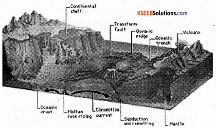
2. The continental slope: The zone of steep slope that descends from the edge of the continental shelf to the deep sea plains is called “continental slope”. It is the transitional zone lying between the continental shelf and the deep sea plains. The continental slope is very steep. It extends from 182 meters to 3.600 meters. The angle of the continental slope is 2 to 5 degre3es or even more. It occupies only 8.5% of the total area of the ocean floor. But it varies from ocean to ocean. The Atlantic Ocean has broader continental slopes and accounts for 12.4%. But it is 7% of the Pacific Ocean and 6.5% of the Indian Ocean.
3. The deep sea plains: The level and rolling areas of the ocean floor are generally called deep sea plains or abyssal plains or the ocean plains. They lie between 3,000 and 6,000 meters below other surface of the ocean. They occupy vast area of the ocean floor and account for about 82.7% of the total sea floor. They cover about 90% in the Indian Ocean. Their depth ranges from 5,000 to 6,000 meters. They are covered by oozes, which are the remains of deep sea creatures and plants, and of red volcanic dust.
4. The Ocean Deeps: The long narrow and deep troughs on the ocean floor are known as ‘ocean deep’ or ‘trough’. They cover only 1% of the ocean floor. They are most common neat the coasts where young fold mountains, volcanoes and earthquakes abound. Some they are tectonic in origin. They are the deepest portions of the ocean. Deeps may be caused due to tectonic forces, i.e. faulting earthquakes etc. There are 57known deeps. Of these 32 are found in Pacific Ocean, 19in the Atlantic Ocean and 6 in the Indian Ocean. The deepest trench in the world is Challenger deep located in Mariana Trench to the west of Philippines in the North Pacific Ocean.
![]()
Question 2.
Explain different parts of the oceans? Give examples.
Answer:
Sea: A part of the ocean either completely or partially enclosed by land is known as a sea. Sea is an enclosed or semi-enclosed body of salt water. In size it is smaller than an ocean. There are partly enclosed seas like the Caribbean Sea, Mediterranean sea, Arabian Sea, Sea of Japan, The coral sea, the Red sea, etc.
Bay: Abay is a wide curving indentation in a coastline lying between two headlands. Examples of bays are the Bay of Bengal, the Bay of Biscay, the Hudson Bay
Gulf: A gulf is an enlarged bay. It is extensive and penetrated far into the land .A gulf is an inlet of the sea, more enclosed than a bay, penetrating further inland. The Gulf of Mexico, the Persian Gulf, the Gulf of Aden.
Strait: A narrow passage of water connecting two larger water bodies is called a strait. Gulf is an enlarged bay. It is a narrow sea passage Joining two larger areas of water bodies. The strait of Gibraltar, the Palk Strait, the Sunda strait, etc. are examples of straits.
![]()
Question 3.
Describe the salient features of Salinity of the Ocean water. (T. B. Qn)
Answer:
Salinity of ocean water refers to the amount of dissolved solids in the ocean water. Ocean water consists of various kinds of chemical elements and minerals. Of these constituents, sodium chloride is the most important constituent of ocean water. The other constituents or salts like magnesium chloride, magnesium sulphate, calcium sulphate, potassium sulphate, etc.
Are also present in the ocean or sea water. The ocean water is saline by the rivers which bring huge amount of mineral salt dissolved in water. Another reason for salinity is the evaporation of sea water, by which mineral salt in the sea or ocean water increase every year. Salinity is measured in gram per kg of sea water and it is expressed as part per thousands for examples: 35% it means 35gram of salt in 1000 gram of sea water.
Factors affecting the salinity in the ocean water are: Evaporation, Precipitation, and Fresh water mixing with ocean water, ground water and glaciers increase the percentage of salt content in the ocean. The trade winds drive away saline water to less saline areas resulting the variation of salt content.
Latitudes, precipitation, mixing of fresh water etc. influence on the horizontal and vertical distribution of salinity. The regions near Tropic of Cancer and Capricorn record high salinity due to high temperature, more evaporation, low rainfall and extensive arid and semi-arid areas. While the equatorial region record low sanity because of high temperature and high rainfall. The polar region record least salinity due to very low temperature, evaporation and less rainfall.
![]()
Question 4.
Explain the types of distribution of temperature of ocean water.
Answer:
Temperature of ocean water has much importance. If affects the climate of coastal areas and it is important for marine plans and animals.The average range of the temperature of ocean water is 12’C. But it is varies from place to place and from time to time. This is due to the regional variation of solar energy, prevailing winds, location of their extent etc.
The distribution of temperature in the oceans varies much owing to the latitude, depth and salinity. It is also much influenced by the prevailing winds, currents and nearness to land masses. The main source of heat for ocean water is the sun. The mechanism of heating and cooling ocean water is quite different from that of land. Ocean water warms up and cools down more slowly the diurnal range and annual range of temperature of ocean water is not significant. The temperature of the ocean water varies from place to place.
Distribution of temperature of Ocean water:
The distribution of temperature of ocean water is of two types. They are:
- Horizontal distribution of temperature of ocean water.
- Vertical distribution of temperature of ocean water.
a. Horizontal distribution of temperature of Ocean water: The temperature of ocean water decreases from the equator towards the poles. This is known as horizontal distribution of temperature.
b. Vertical Distribution of Temperature: The decrease in temperature from the ocean surface with increasing depth is known as vertical distribution of temperature.
Question 5.
Explain the factors influencing on the salinity of the ocean water.
Answer:
Salinity of ocean water refers to the amount of dissolved solids in the ocean water. Ocean. water consists of various kinds of chemical elements and minerals.
The distribution of salinity is described both horizontally as well as vertically. Salinity in the ocean water varies from one place to another as well as with the variation of the depth. The amount of salinity to a large extent is determined by the difference between precipitation and evaporation.
a. Evaporation: The amount of salinity and evaporation are directly related. The process of evaporation of water results in the precipitation of salt. Hence higher the amount of evaporation more will be the amount of salinity. Salinity is highest in the belt of tropics, as there is the is excessive evaporation. In the Atlantic Ocean salinity is about 37% near the tropics.
b. Precipitation: In the region of heavy rain fall and cloudiness, more freshwater is added to the ocean water and also the amount of evaporation is reduced. So the amount of salinity is much lower. In the equatorial region the amount of salinity is 35% equivalent to the average of the world.
c. Flow of river water: In the coastal regions where freshwater of rivers enters the sea salinity is greatly reduced.
d. Movement of ocean water: There is a vertical movement of water due to the variation of salinity. On the surface water. Salinity is higher and it sinks due to density and the water rises up from below. Similarly light water from the oceans enters the enclosed seas and dense water flows towards the open seas.
e. Winds: Prevailing strong winds drag surface ocean water and cause the rise of water from below. Thus it reduces the amount of salinity.
![]()
Question 6.
Explain the Indian Ocean currents with the help of Maps. (T. B. Qn)
Answer:
Indian Ocean is different from other ocean in the pattern of its current. This is due to the size of the Indian Ocean, the position of land masses and the seasonal change in the direction of monsoon winds. This is true of the North Indian Ocean. But in the south Indian Ocean, the currents flow as in the Atlantic Ocean and Pacific Ocean.
a. North Indian Ocean currents: The north Indian Ocean currents change their direction. twice a year as result of the alternating monsoon winds greatly influence the ocean currents in summer. The current flows off from the coast of Somali as the Somali current and drifts across the Arabian Sea as the south-west monsoon drift. Finally it joins the North Equatorial current and completes a clockwise circulation.
In winter, the North east winds influence the currents. Hence the currents starting form the stair of Malacca flows along the eastern and western coasts of India as “North East Monsoon Drift” and west ward. Then it turns near the Gulf of Aden to the west flows towards the south and turns east wards near the equator, finally it joins the North Equatorial Current and completes an antilock wise circulation.
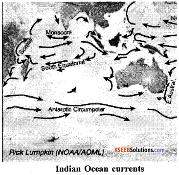
b. South Indian Ocean currents: The currents of the south Indian Ocean are not affected by the monsoon winds. So the current of the south Indian Ocean are similar to those in the southern part of the Atlantic Ocean and Pacific Ocean. In the south Indian Ocean, the South-East trade winds blow towards the west and give rise to the equatorial current, i.e. the south equatorial current.
On reaching the eastern coast of Africa, it flow southwards and is divided in two to branches, as it is obstructed by Madagascar Island. One branch enters the Mozambique current. The other branch flows eastwards of Madagascar Island and is known as ‘Madagascar current’. These two currents join again. And flow southwards as the Agulhas current. At 40 S latitude under the influence of the westerlies, it flows eastwards as West wind drift. It is also known as Indian Ocean current.
On reaching Australia, it divides into two branches, One branch turns northwards along the west coast of Australia as the west Australian current. Again turns west and North West, and finally joins the south equatorial current. The other branch moves to the southern coast of Australia and enters the Pacific Ocean.
![]()
Question 7.
Briefly explain the types of tides. (T. B. Qn)
Answer:
The regular and periodic fall and rise of the ocean water is called tides. The rising of water level is known as high tide or flood tide. The falling of water level is known as low tide or ebb tide. The difference between the high tide and low tide is called tidal range or range of tide.
Types of Tides:
There are different types of tides. The important types of tides are as follows:
1. Spring tides: Spring tides occur when the earth, sun and moon are more or less in a straight line. This happens on a full moon day. When the earth is between the sun and the moon or on a new moon day, when the moon is between the sun and the earth. The combined pull of the sun and moon on the earth is very great, and it produces very high tides and very low tides. Such tides are called spring tides.
2. Neap Tides: When the earth, sun and moon are not in a straight line, the sun and the moon are not exerting combined force.
3. So, the gravitational pull is much less. At half moon, the force exerted is the minimum. On the ocean water. Consequently the high tides are not very high and the low tides are not very low. They are called “Neap tides”.
![]()
Question 8.
Explain the uses of tides.
Answer:
The tides are very useful to man in many respects. The main uses are as follows:
- Tides help large ships to enter ports and encourage trades.
- The tides help to keep the harbors clean. The high tides take away the sewage and refuse from the port as well as from mud and silt from river mouths.
- The tides are used to generate electricity and thermal units. They provide inexhaustible and pollution free energy. Example: in Japan and France.
- Tides also help fishermen. They can go out for fishing with the low tide and come back with the high tide. Further tides play an important role in the distribution of plankton and helps in fishing.
- Tides prevent the freezing of seawater along the coast and mouths of rivers.
- Tides helping in producing salt in the coastal area, as water are collected by high tide in the low lying areas.
- Tides prevent the freezing of seawater along the coast and mouths of rivers.
- The ebb tides prevent the harbors to be silted.
- The energy of tides can be utilized for generating hydroelectricity.
- Tides are responsible for eroding the coastline and removing the debris to the sea.
![]()
Question 9.
What is Conservation of Ocean? Mention the important measures. (T. B. Qn)
Answer:
Conservation of ocean means rational uses of ocean resources. So that a harmony between man’s ocean resource requirements and their availability could be maintained. The rational uses of ocean resources by the present generation and the preservation of ocean resources for the future generations, is known as conservation of ocean. It also means the protection of oceans and ocean resources against pollution caused by dumping of oceans and of industrial, agricultural and municipal wastes into oceans by man, oil spill from oil tankers, and nuclear explosions in sea and oceans.
Need for conservation of Oceans: There is a need for conservation of oceans due to the following reasons:
- If oceans are not conserved, all the living organism in the oceans either die or become unsuitable for human consumption.
- Oceans are the storehouse of pearls, corals and sponges. These resources have to be conserved.
- Oceans have oil and natural gas reserves. These reserves have to be conserved.
- Oceans are rich in minerals. These mineral resources have to be rationally exploited.
- Oceans allow the growth of innumerable species of plants. These plants have to be conserved.
- Oceans are the breeding centers of marine fisheries. Thousands of fishes are found in oceans. The marine fishery resources should be exploited rationally.
- Literacy and education programmes on marine features must be initiated and promoted.
- Proper law to be enacted to save sea and ocean.
World wise awareness programme must be arranged to show the pro and cons of the marine pollution etc.
![]()
Question 10.
What is Ocean? Write the uses of Ocean.
Answer:
Ocean refers to the large mass of salt water. About 71% the earth’s surface is covered by water and the remaining 29% is converged by land. There are five important oceans in the world. The five oceans in the order of their sixe are the Pacific Ocean, the Atlantic Ocean, the Indian Ocean, the Antarctica ocean and the Arctic Ocean. The Pacific Ocean is the largest ocean with an area of 166.3 million swq.kms and an average depth of 4kms.
The Atlantic Ocean is the second largest ocean lying between America and Europe and Africa. Its average depth is 3kms. The Indian Ocean is smaller than the Atlantic Ocean. The Antarctic Ocean surrounds the continent of Antarctica.
The Arctic Ocean lies in the north pole region. Uses of Oceans:
The major uses of oceans are:
- Oceans are a very high source of energy. Offshore wells provide petroleum and natural gas, ocean tides can be used to produce hydro-electricity.
- Ocean water can be used for domestic purposes after desalination, which is possible through modern technology
- The marine life provides valuable medicines.
- Oceans encourage commercial fishing.
- Oceans promote ports and harbors and encourage ship-building.
- The provide corals, pearls and shells and sponges
- Oceans serve as natural frontiers and protect a country from foreign invasion.
- Ocean serve as place for dumping wastes.
- Ocean are the source of water vapor and precipitation in general. The winds blowing form the oceans bring rainfall.
- Oceans have a direct control over temperature. This is clear form the fact that the coastal areas are cooled in summer and warmer in winter.
- Oceans are a rich source of food in the form of protein from fish, mammals, sea weds etc.
- Oceans have an abundance of salt and other chemicals, such as sulphate potassium chloride, magnesium chloride etc.
![]()