Students can Download 2nd PUC Geography Previous Year Question Paper June 2015, Karnataka 2nd PUC Geography Model Question Papers with Answers helps you to revise the complete Karnataka State Board Syllabus and score more marks in your examinations.
Karnataka 2nd PUC Geography Previous Year Question Paper June 2015
Time: 3 Hrs 15 Min
Max. Marks: 100
I. Answer the following questions in one sentence each: (10 × 1 = 10)
Question 1.
State the total population of the world according to 2012.
Answer:
World population as per 2012 was Seven billion.
Question 2.
What is an Industry?
Answer:
The process of conversion of raw materials into finished goods employing machinery and man power is called as industry.
Question 3.
What is Water Transport?
Answer:
The method of carrying goods and passengers on boats, ships, steamers etc on water from place to place is water transport.
Question 4.
What is a Megacity?
Answer:
Megacity is a metropolitan area with a total population of more than 10 million.
Question 5.
Which State recorded the highest literacy in India?
Answer:
Kerala is the state which has recorded the highest literacy rate with 93.91%.
![]()
Question 6.
What is Irrigation?
Answer:
The supplying of water to the crops through various means like canals, tanks etc is irrigation.
Question 7.
Which is the highest coffee producing state in India?
Answer:
Karnataka is the highest coffee producing state in India.
Question 8.
Name the metal which is made of bauxite ore.
Answer:
Aluminium is the metal which is made from bauxite ore.
Question 9.
Which city of India is known as Silicon Valley?
Answer:
Bengaluru is called the silicon valley of India.
Question 10.
Which is the Headquarters of South-Western Railway?
Answer:
Mumbai (Church gate).
II. Answer any ten questions in 2 to 3 sentences each: (10 × 2 = 20)
Question 11.
Name the types of Human Economic Activities.
Answer:
- Primary activities
- Secondary activities
- Teritiary activities
- Quaternary activities.
Question 12.
Give the importance of Industries.
Answer:
- They provide employment to a lot of people.
- They help to modernize the agricultural sector by providing tractors, fertilisers, manures and scientific technology.
Question 13.
Give two examples of administration towns.
Answer:
- New Delhi
- Canberra
![]()
Question 14.
Name the types of migration.
Answer:
- Internal migration
- International migration
Question 15.
What is Green Revolution?
Answer:
Increase in food production through the introduction of high yield crop varieties and application of modem agricultural techniques is called Green Revolution.
Question 16.
Mention the types of coal.
Answer:
The types of coal are as follows.
- Anthracite
- Lignite
- Bituminous
- Peat
Question 17.
Which minerals are used for producing Nuclear Energy?
Answer:
- Uranium
- Thorium
- Plutonium
Question 18.
Mention the importance of Aluminium.
Answer:
- It is light weight strong and rust resistant,
- It is used in aircrafts, automobiles.
- It is mainly used in electrical industry as it is a good conductor of electricity.
Question 19.
Name the two air transports in India.
Answer:
- Internal Air transport or The Indian Airlines.
- International Air transport or The Air India.
Question 20.
Mention the advantages of Television.
Answer:
- Television educates millions of people through advertisement.
- It is a source of entertainment.
- It makes a personal appeal and transmits messages directly into the homes of the viewers.
- Events happening at different parts of the world can be seen within minutes or even seconds thanks to news coverage.
Question 21.
Name the types of pollution.
Answer:
- Air pollution
- Water pollution
- Land pollution
- Noise pollution
Question 22.
What are the causes of Air pollution?
Ans:
- Increased use of varieties of fuels such as coal, petrol and diesel in vehicles and machines.
- Increase in emission of toxic gases from industrial activities.
- Mining activities release dust in the air.
- Important pollutants such as hydrocarbons, carbon dioxide, carbon monoxide which lead to air pollution.
![]()
III. Answer any eight of the following questions in 25 to 30 sentences each: (5 x 8 = 40)
Question 23.
Explain the importance of Human Geography.
Answer:
Scope of human Geography:
As early societies became more successful in meeting their need with in permanent settlements.
- The rise of agriculture activities resource extra and manufacturing activities led to more complex economic and political boundaries were created and more settlement grew into towns and cities.
- The physical environment also changed with the influence of modem urbanize and industrialized world that we known today.
- One of the greatest challenges faced by humans today is how to manage energy resource in a sustainable fashion without inflicting permanent damage to environment in the form of land, air, water, pollution and climatic changes.
Importance of Human Geography:
- It clarifies the societies and cultures in different ^locations.
- The great diversity reflects through the fashion life.
- Which realizes carrying capacity of the Earth.
- It helps us to understand circumstances affecting people and nation.
- It is helpful to the planners, administrations, Industrialists and others. ’
Question 24.
Explain the growth of population in the world.
Answer:
- The growth of population refers to the increases in the number of inhabitants of a country during specific period.
- It is estimated that the world population reached one billion for the first time in 1804.
- Due to the impact of the industrial revolution & improvement in living standards, the rate of population growth increased two billion in 1927.
- At present estimate of 2013 the globe is inhabited by 7121 million population.
- During the begining of 20th century the world population was only 2 billion and centum ended with 6 billion. It continues to grow even in the 21st century.
Stages of Population growth:
I Three billion – July 1959
II Four billion – April 1974
III Five billion – July 1987
IV Six billion – October 1999
V Seven billion – 12th March 2012.
Question 25.
Explain the stages of Demographic Cycle.
Answer:
Demographic cycle is the process of population transformation from the countries of high birth rate and high death rates to low birth rate & low death rate countries.
Stages of Demographic cycle:
1. First stage: High birth rate and high death is found when the country is economically most backward, so the population remains stationary. India was in the stage till 1920.
2. Second stage (Early expanding): It begins with the declining of death rate while the birth rate remains unchanged. These changes due to the advancement of science & technology, basic healthcare and education etc. At present many developing countries of Asia & Africa are in this stage.
3. Third stage (Late expanding): Death rate declines and birth rate begins to fall due to access of contraceptives, urbanization, an increase in the status and women education etc India appears to be this stage.
4. Fourth stage (Low stationary): It is characterized with low birth rate and low death rate. Growth is stationary due to changing life style, high obesity and many diseases are. caused in this stage. Japan, Sweden, Belgium Denmark & Switzerland are in this stage.
5. Fifth stage(DecIining): Population begins to decline or birth rate is lower than deathrate. East European countries like Germany and Hungary and North European countries like Sweden, Norway are now in this stage.
Question 26.
Explain the world distribution of Railways.
Answer:
Europe has the highest density of rail. Network in the world. It has about 4,40,000 kms of railway track.
- Marmary is the first continental under water railway line. It is between Asia and Europe. It is about 13Kms through Bosporus strait (sea of Marama) & was opened in 2013.
- Railways are more in Russia. From Moscow major lines radiating to different parts of the Country.
- North America has one of the most extensive rail Networks accounting for nearly 40% of the World’s total.
- Chile rail route connects the coastal centres, mining centres as well as interior. Peru, Bolivia, Eurador, Colombia, Venezuela.
- In Asia rail Network is the most dense in Japan, China & India. Japan has 20,035 kms of rail routes.
- Africa has 82,000 kms of Railway route in which 18000 kms lies in South Africa alone due to the concentration of gold, diamond and copper mines. Africa has many major railway route which connects Benguela, Katanga, Zambia, Botswana, Zimbabwe.
- The Tranzam-great Churn railway is connecting the Copper mines of Zambia with the port of Dar-es-Salam of Tanzania.
- The Benguela railway links the Copper mines of Zaire with the Atlantic coast ports via Angola.
- The Blue train run for from Cape Town to Pretoria in the republic of South Africa.
- The Algeria, Senegal, Nigeria, Kenya, Ethiopia railway lines connects the port cities to interior centres.
Question 27.
Explain the factors affected on Human development Index in India.
Answer:
Factors influencing on HDI of India are discussed below:
1. Birth and Death Rate: Declining of birth rate has been much slower than that of the death rate. This results in rapid increase of population. It affects on slow economic growth of the country. It is the main cause for declining of human development index.
2. Life Expectancy: Life Expectancy has gone up 65.77 years for males 67.95 years females respectively in 2011-12. This is due to the consequence of the expansion of food security and medical facilities. It helps to raise the HDI in the country.
3. Food and Nutrition: According to the 2011 Global Hunger Index (GHI) report, India has 15th rank among the leading countries with hunger situation.
- The World Bank estimates that India is one of the highest-ranking countries in the World for the number of children suffering from malnutrition.
- It is adversely affecting the Human development.
4. Literacy: Education is the key for socio-economic progress. The Indian literacy rate grew to 74.04% in 2011 from 12% at the end of the British rule in 1947. The large proportion of illiterate females is another reason for the low literacy rate in India. Due to this there is decline in the Human development Index of the country.
5. Poverty :
- India suffers from a lot of Poverty which means that many people here do not have enough money.
- Poverty has reflected in poor quality of life, hunger, malnutrition, illiteracy and consequent low level of human development.
![]()
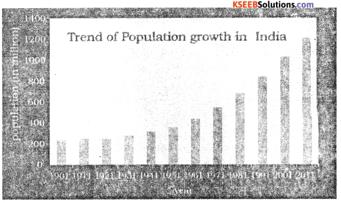
Question 28.
Explain the trend of population growth in India.
Answer:
The Population growth in India between 1901 and 2011 can be divided ‘into four stages as
follows.
1. 1901 – 1921 Stagnant population growth.
2. 1921 -1951 Steady growth.
3. 1951 – 1981 Rapid high growth.
4. 1981 -2011 High growth with definite signs of slowing down.
1. In the first stage: In this decade, population growth was naturally curbed with the outbreak of Plague, Cholera. Malaria, influenza and other epidemics. Thus the decade is considered as ‘the great divide in the history of Indian Census
2. In the second stage: The population can be considered as moderate The population • grow ing from about 251 million (1921) to 361 million (3951), an increase of about 110
million. The main reason was decline in death rate due to control of epidemics like Plague, Cholera etc.
3. The third stage: is very important, because of the growth rate of population is very high. The Population grew from .361 million (195 1) to 686 (1981). an increase of about 325 million The growth has been very rapid after independence. The government of India was implemented many Socio-Economical Programs in all sectors.
4. The fourth stage: It completely differs from other three stages. Here the trend of growth rate of population is gradually slowing down. We can easily justify that, the period from 1981 to 2011 is referred to as a high growth with definite signs of slowing down.
Question 29.
Explain the Canal Irrigation in India.
Answer:
India has one of the largest canal systems of the world. Canals are the second largest source of irrigation in the country.
Canals are of two types :
1. Inundation canals : taken out directly from rivers, without making any barrage or dam.
2. Perennial canals: which are taken out from the reservoirs by constructing barrage or weir to regulate the flow of water.
- Canal irrigation is widely practiced in the Sutlej Gangas plains and the deltas of the peninsular rivers.
- Nearly 79% of India’s canals irrigated area lies in Uttar Pradesh, Rajasthan, Andhra Pradesh,Haryana, Punjab, Madhya Pradesh etc.
- Uttar Pradesh ranks first in India where canal irrigation is most extensive. Canal irrigation suffers from a number of draw-backs such as water logging, increase in water table, alkalinity of soils due to capillary action etc.
Question 30.
Explain about Rain Water Harvesting.
Answer:
- Controlling the runoff of rain water and make it to perculate to increase ground water table for future purpose.
- It involves collection and storage of rainwater at surface or in sub-surface aquifier, before it is lost as surface runoff. It not only increases water availability but also checks the declining water table.
Objectives: The following are the main objectives of rain water harvesting.
- It checks runoff water & avoid flooding.
- It replenishes the ground water table and enables the wells.
- It helps to overcome the adequancy of surface water to meet demand of water.
- If the ground water is blackish, it will reduce the salinity.
- It also reduces ground water contamination and improve water quality.
- It helps to increase agricultural product and improves ecology of an area.
Methods of Rain Water Harvesting :
1. In-situ method The method of percolating the rain at the point of its fall itself is called In-situ rainwater harvesting.
For example
- Infiltration pits: The rain water can be collected and stored in pits, dug in farm lands and used for irrigation.
- Contour bunds and trenches: The Construction of bunds, trenches or check dams.
- Roof top water harvesting : The Rain water that falls on the roofs of buildings or in courtyards is collected and stored in underground. Sumps, or wells or in drums and used for domestic purpose such as cleaning, washing etc.
2. Ex-situ method: This method of rainwater harvesting involves storing of running water. It is collected in check dams, huge percolation tanks etc. It is an expensive method.
Question 31.
Explain the importance of Agriculture in India.
Answer:
Agriculture is the most important Primary activity and the oldest occupation of human beings in India.
- Main source of livelihood: About 70% of the people directly and indirectly depend on agriculture for their Livelihood.
- Food supply: Agriculture provides food grains, fruits, vegetables, spices etc to the people and fodder for the animals.
- Provides employment facilities: Agriculture is largest sector providing highest employment.
- Source of National income: It contributes to the national income .of the country.
- Source of raw materials for Agro-based-industries ex: Raw cotton, sugar cane and Jute.
- Source of large amount of revenue to the government.
- Support to tertiary sector like transport, communication, banking, insurance etc.
- Help to internal trade like Agricultural products are transported from the area of surplus production to the area scarcity.
- Support to export, many agricutlural products produced in the country are exported i.e. tea, coffee, Jute, Tobacco etc.
- Political & Social situation in the country is determined by the agricultural production
Question 32.
Explain the production and distribution of cotton in India.
Answer:
Production and distribution of cotton in India:
Cotton is grown in different parts of the country. Gujarat, Maharastra, Andhra Pradesh and Haryana are the major cotton producing states.
1. Gujarat: Gujarat is the largest producer of cotton in India, which is due to the better yield per hectare i.e 689 kg per hectare. Bharuch, Surendemagar, Vadodara and Ahmedabad are the important cotton growing districts.
2. Maharashtra: Maharashtra ranks first in cotton growing area and it stands second in the production of raw cotton in the country. Over 80% of its cotton production comes from Khandesh, Vidarbha and Marathwada regions.
3. Andhra Pradesh: It is the third largest producer of cotton in India. The leading cotton producing districts are Guntur, Prakasam, Adilabad, Kurnool and Anantapur.
4. Haryana: Haryana stands in the fourth place of cotton production in India. It has the highest yield per hectare of cotton in the country i.e. 703 kg. Gurgoan, Hissar, Rohtak and are the major districts.
![]()
Question 33.
Explain the various types of roads in India.
Answer:
Classification of roads: In India, roads are of the following types.
- National highways,
- State highways,
- District roads and
- Village roads.
Besides these, there are border roads and International highways linking major Indian cities with the capitals of other neighbouring countries.
National highways:
- They connect the capitals of the states, industrial centres and major ports.
- They are well planned wide roads with two-lane, four-lane, and six-fane roads. Both construction and maintenance are carried out by the Central Government and National Highway Authority of India [NHAI],
- The total length of the national highways is about 71,772 km as per 2011.
- (i) The Golden Quadrilateral,
(ii) The North South and East West corridors,
(iii) Port connectivity with industries are all parfbf this network.
1. Golden Quadrilateral Super Highway: The Government of India has implemented a major road development project linking Delhi-Kolkata-Chennai-Mumbai by six-lane super high-ways. It has a total length of 5846 kms and it is called as Golden Quadrilateral Super Highway.
2. North – South and East-West corridors: This project connects Srinagar (JK) in the North with Kanyakumari (TN) in the South and Silcher (Assam) in the East with Porbandar (Gujarat) in the West covering major cities along the way. The project has a total length of 7300 km.
3. Port connectivity project: This is also included in the programmes of NHAI. This project connects the Golden Quadrilateral roads with the 13 major ports (380 km) and other projects (962 km). This is still in progress.
4. State Highways: The State Highways connect the important cities of the state with its capital, with the national highways and link with other state capitals. The State Government is responsible for the construction and maintenance of the State Highways. Now there are about 1.54, 522 km length of the state highways in the country.
5. District roads: These roads connect the production and marketing centres with the highways, railways, towns and larger villages with the district headquarters. The Zilla Parishad takes the responsibility of the development and maintenance of these roads.
6. Village roads: Roads which link the taluk headquarters with villages and the district highways are called village roads. They are mostly untarred or metalled. They are constructed and maintained by Taluk Panchayats and Village Panchayats.
7. Border roads: Border roads are constructed in the border areas of the country. They are constructed in the North and North eastern border areas adjoining Pakistan, Nepal, Bhutan and Bangladesh. These are mainly for army movement in the defence of the country.
8. International highways: Some of the national highways of the country have been linked with the international highways of the neighbouring countries.
Question 34.
Write about the causes of Water Pollution and effects of Water Pollution.
Answer:
Causes of water pollution: Water pollution is caused by natural and human sources.
- Natural sources of water pollution are due to erosion, landslides, gases, soil, minerals.
- Human excreta, waste created by animals and other living organisms and rotting vegetation are also some causes. More than natural sources, water pollution is largely caused by human activities.
- Humans pollute water through industrial, agricultural and cultural activities. Among these, industry is the worst culprit.
- Industries produce a variety of waste products including industrial wastes, polluted water wastes, poisonous gases, chemical residuals, numerous heavy metals, dust, smoke etc.,
- Most of the industrial wastes are disposed off by running water. Consequently poisonous elements reach the lakes, river and other water bodies, which destroy them.
- Reservoirs -They in turn destroy the bio-systems of the water. Major water polluting industries are leather, pulp and paper, textiles and chemicals.
- Fertilizers, pesticides and insecticides, farm wastes and mineral particles from agricultural lands are washed down and end up in rivers, lakes and tanks.
- The chemicals also infiltrate into the soil to reach the ground water.
- Addition of fertilizer increases the nitrate content of surface waters.
- Religious and cultural activities like pilgrimages, fairs, tourism, immersion of idols after pujas etc., also cause water pollution,
- Urban activities such as improper sewage disposal also cause water pollution.
- Effects of water pollution: Water pollutants adversely affect the health of humans, animals and aquatic life.
- Water pollution is a source of various water borne diseases like diarrhoea, intestinal worms, hepatitis etc.
- World health organization shows that about one fourth of the communicable diseases in India are diseases water borne.
IV. Answer any one of the following: (1 × 10 = 10)
Question 35.
Describe the non-conventional energy resources in India.
Answer:
The Power resources other than the traditional fossil and Mineral sources are known as ‘Non Conventional Power Resources’. They include Solar energy, Wind energy, Bio-gas, Sea waves, Biomass and geo-thermal etc. These reasources are inexhaustible and renewable in nature.
Importance :
- These Power resources are found in abudance, pollution free, eco-friendly and not harm to the eco-system.
- They can be very conveniently supplied to urban as well as rural areas.
- In India conventional power resources are inadequate. Recently the rate of energy consumption has been increased.
- Hence there is urgent need to harness other alternative power resources.
- Top priority has been given for the development of non-conventional power resources.
- They are capable of solving the requirements. Such as supply of energy in decentralized manner and have sustainable environment.
- Thus the development of the these power resources is very essential.
Question 36.
Explain the localization factors of industries.
Answer:
Some important factors are:
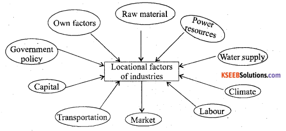
- Raw materials Industries are set up close to or in the regions where raw materials is available.
- Power Resources Power is essential for running the machinery of industries and influences much on the industrial location.
- Water supply Large quantities of water essential for the processing of raw materials or for cooling purposes. Therefore industries are usually localized near rivers or lakes.
- Climate: Industries are influenced by climate. For example Cotton textile industry requires humid climate.
- Labour Cheap and efficient labour is required to work in the industries.
- MarketNearness to market is essential for quick marketing of manufactured goods.
- Transportation It is necessary to carry raw materials to the factories and to carry finished products to the markets as well.
- Capital Development of Industries requires large capital investment.
- Government must have favourable policies such as tax exemptions electricity and sites at concessional rates, subsidies, rail-link, improved roads etc.
![]()
V. Answer any two of the following: (2 x 10 = 20)
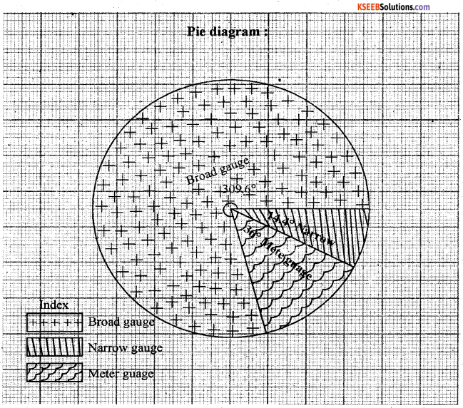
Question 37.
Represent the following data by a Pie diagram
| Types of Railway Gauges | Percentage |
| Broad gauge
Meter gauge Narrow gauge |
86
10 04 |
| Total | 100 |
Answer
Broad gauge = \(\frac { 86 }{ 100 }\) × 360 = 309.6
Meter gauge = \(\frac { 10 }{ 100 }\) × 360 = 36
Narrow gauge = \(\frac { 4 }{ 100 }\) × 360 = \(\frac { 14.4 }{ 360 }\)
38.
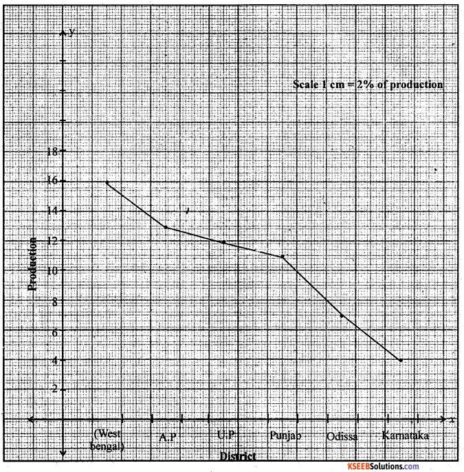
Construct a simple line graph to represent the following data.
India : Selected Statewise Rice Production (in percentage)
| States | Production % |
| West Bengal | 15.80 |
| Andhra Pradesh | 12.71 |
| Uttar Pradesh | 11.91 |
| Punjab | 10.86 |
| Odissa | 7.31 |
| Karnataka | 3.70 |
Answer:
Question 39.
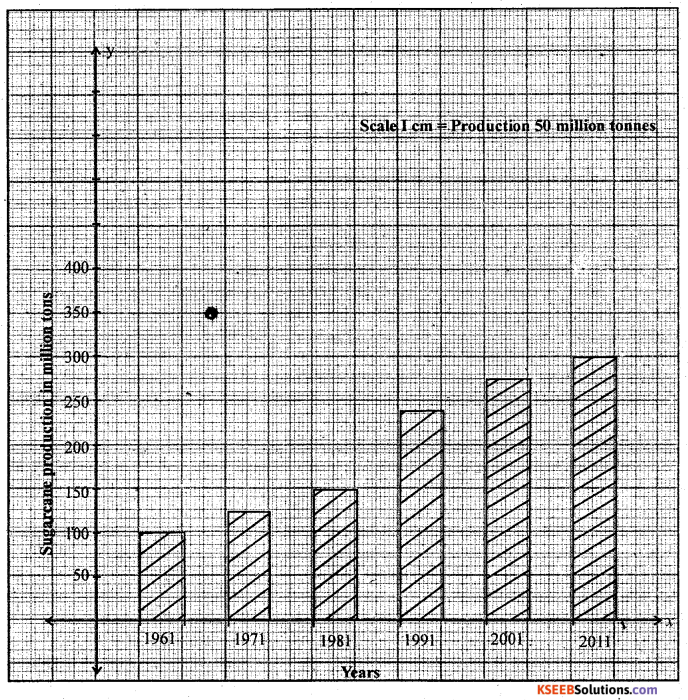
Construct a simple bar graph to represent the following data:
India : Decadewise Sugarcane Production (in million tonnes)
| Year | Production (in million tonnes) |
| 1961 | 110.00 |
| 1971 | 126.36 |
| 1981 | 156.24 |
| 1991 | 241.04 |
| 2001 | 286.00 |
| 2011 | 310.00 |
Answer:
Blind Candidates only
Question 40.
Answer any two of the following questions: (2 x 10 = 20)
(a) Write the importance of Remote Sensing.
(b) Explain the functions of GIS.
(c) Explain the functions of GPS.
Answer:
(a) Remote sensing is the science and art of obtaining information about an object, area or phenomenon through the analysis of data acquired by a device that is not in contact with it. This is done by sensing and recording reflected or emitted energy and processing, analyzing and applying that information.
In much remote sensing, the process involves an interaction between incident radiation and the targets of interest. This device can be a camera or a bank of sensors operated from an airplane or a satellite. Though satellite we can collect date related agriculture, forest, urban land use, water, natural calamities etc the satellite data is based for mapping, monitoring, studying the various phenomena related to earth’s surface. –
(b) 1. Capture data: Geographical data can be collected/captured from various sources like hard copy, map through top sheet, digital data, through GPS, Secondary data through published tables.
2. Storing data: Geographical data once captured, it needs to transform from Analogy into digital format and to be stored in computer for further analysis.
3. Query: Once you have a functional GIS containing your geographical information, you can begin to ask a simple questions.
4. Analysis: There are 3 types
- Proximity Analysis: Proximity queries find features with in a certain distance of other features.
- Overlay Analysis: It is simplest, this could be a visual operation, but analytical operations require One or more data layers to be joined physically.
- Network Analysis: A network is a set of edges and junctions that are Topologically connected to each other.
5. Display: Once analysis is done maps, diagrams, graphs and tables are to be designed and same has to be displayed over computer moniter.
6. Output: This is final, stage of GIS function where in the maps, data tables etc… can be printed to have hard copy as output.
![]()
(c) There are three segments of GPS:-
1. The space segments : The satellites of GPS are launched and positioned at an altitude of approximately 20200 km which is almost more than three times of the earth’s radius. The space segment consists of a constellation of 24 functioning GPs satellites located in 6 orbital plane with 4 satellites in each orbital plane. The time for the satellite to complete
one revolution around the earth is 11 hrs and 58 minutes.
2. The control segment: The control segment consists of facilities necessary for satellites especially healthy monitoring, telemetry, tracking command and control clock error ‘ computation .of satellites. There are 5 GPS stations spread over the earths surface they arc
- Hawaii
- Colorado spring
- Ascension Island
- Diego Garcia
- Kwajalein.
3. The user segment: It is a total user and supplier community, both civilian and military. The user segment consists of all earth – based GPS receivers. Receivers very greatly in size and complexity, through the basic design in rather simple. The space and control segments are largely transparent to the operations of navigation functions.
1. Navigation: In navigation, by using GPS can save countless hours in the field. Any feature, even if it is under water, can be located upto one hundred meters simply by scaling coordinates from a map, entering way points & going directly to site.
2. Remote sensing and GIS: GPS positioning can be integrated into remote – sensing methods such, as Photogrammetry and aerial scanning, magnetometry, and video technology using DGPs techniques. ,
3. Surveying/Mapping: The high precision of GPS carries phase measurements, together with appropriate adjustment algorithum, provides an adequate tool for a variety of tasks for surveying and mapping.
4. Geodesy: Geodetic mapping and other control surveys can be carried out effectively using high grade GPs equipment.
5. Military: The GPs was Primarily develped for real time military positioning. Military applications include airbone, marine and land navigation.