Geographical Features & Pre-Historic India Class 8 Questions and Answers KSEEB 8th Social Science
I. Complete the following sentences.
Question 1.
Geographically India is a ______________ .
Answer:
sub-continent.
Question 2.
Signs of ashes have been found in the caves of ______________ .
Answer:
Kurnool.
Question 3.
The tools of the middle stone Age are called ______________ .
Answer:
delicate stone tools age.
![]()
II. Answer the following questions in brief
Question 1.
Describe the geographical features of India briefly?
Answer:
India’s geographical features comprise the Himalayan Mountains, the Indo – Gangetic plain in the north. The Deccan plateau and the coastal region in the south. Himalayan Mountain: In the north snow capped mountain, consisting of tallest trees and mountain peaks.
They help us, and provide safety and security. The Narmada river divides into 2 parts, Malwa plateau or central highlands and the Deccan plateau in the south.
Question 2.
Which are the valleys through which the attacks on India have taken place?
Answer:
The attacks have been mainly from the north- western side through the valleys of Bolan and Khyber passes.
Question 3.
What is meant by prehistoric age?
Answer:
The period before the discovery of the art of writing is called the pre-historic age.
Question 4.
How did animal husbandry and dairying start?
Answer:
Humans who had been hunting animals, began to observe their nature, food habits and the way these animals multiplied over a period of time, they captured some animals and brought them up.
Question 5.
The different periods of prehistory have been various names by archaeologists. What are they?
Answer:
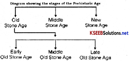
Prehistoric age is classified into 3 stages. They are
- Early stone age.
- Middle stone age.
- New stone age.
![]()
Additional Questions and Answers
Question 1.
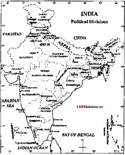
Draw a India map and locate the following places on it.
(a) Madhya Pradesh.
(b) Karnataka.
(c) Himalayas
Answer:

Question 2.
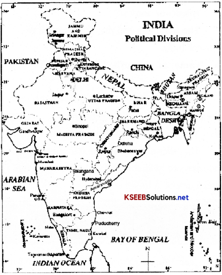
Draw an Indian political map and mark the bounderies of the following countries.
(a) Nepal
(b) China
(c) Bangladesh
(d) Pakistan
(e) Arabian Sea
(f) Indian Ocean
(g) Bay of Bengal
(h) Andaman Nicobar Island.
Answer:

![]()
Question 3.
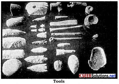
Write a neat diagram of tools which were used in the prehistoric period.
Answer:

Question 4.
Draw a neat diagram showing the stages of the prehistoric age.
Answer:

Question 5.
Name the Neighbouring countries of our country?
Answer:
Pakistan, Afghanistan, China, Nepal, Bhutan, Bangladesh and Myanmar Are our neighboring countries.
Question 6.
How many states and union territories are there in our Country?
Answer:
There are 29 states and 6 union territories.
Question 7.
Name the two important passes of our country?
Answer:
Bolar and Khyber are the two important passes of our country.
Question 8.
Which river separates India into 2 parts?
Answer:
The river Narmada separates India into 2 parts.
![]()
Question 9.
Name any two ancient dynasties that ruled our nation?
Answer:
The Maurya’s and the Guptas ruled over ancient India.
Question 10.
Name any south Indian rulers or kingdoms.
Answer:
Pandyas the Chouryas and the Cholas are the famous south Indian kingdoms.
Question 11.
Where did the prehistoric man live?
Answer:
The relics of the hunting and food gathering humans are available in Bimbetka, Hunasagi and Kurnool in India.
Question 12.
Where do we see industrial sites in pre-historic age?
Answer:
Usually we get to see stone tools around rocky areas.
Fill up the blanks with suitable answer.
Question 1.
__________________ people had learnt to weave cloth.
Answer:
The new Stone Age
Question 2.
The eastern coastline is known as __________________.
Answer:
Coramandal coast
![]()
Question 3.
The western coastline is referred as ____________ and ______________.
Answer:
Konkan and Malabar coast